Here comes a last update from this summer’s field work, by a guest author – I worked in Metsähallitus’ inner archipelago team this summer, first helping out on the surface when the divers mapped reefs, and then mapping transects in shallower flads (lagoons) and bays myself by snorkelling. I also mapped Regions Of Interest (abbreviated ROI) in addition to the normal snorkelling lines – interesting areas mostly consisting of wide reed belts with varying amounts of open water in small “ponds” inside the reed belt. Since this kind of mapping can be a bit different from mapping of the rest of the bay, that is what I’ll describe here, using two of the more memorable ROIs as examples.
Satellite Image of a Region Of Interest (in Sahanlahti): The open areas in the reed belt are the ones I was looking at. Satellite images can be deceiving though – this must have been taken a few years ago, and now there was more reed than in this picture (the little bay in the upper right corner for example was no longer open). Picture: Google Maps satellite image
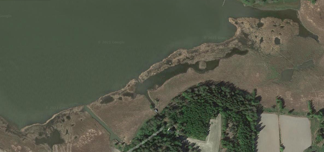
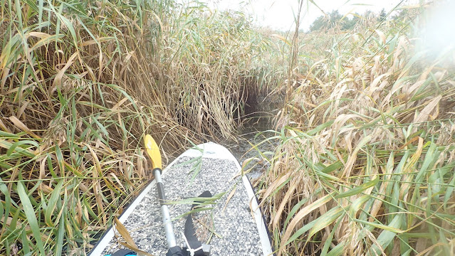
Sahanlahti is a bay in Kaarina/S:t Karins with a broad reed belt along the shore, more than 600 meters long, containing several smaller ponds and openings. Normally while mapping I kept all my field gear on a SUP-board and paddled from one place to another – paddling in this reed belt ended after the first few ten meters or so, after that I had to hop off and drag the SUP with the field gear behind me through the reed for the rest of the mapping. The reed was quite dense and the water depth in areas between openings was low, sometimes just wet ground. It was not a very fast way to move forward but it worked better than I expected, since the bottom was firm enough and not just loose mud to sink down in. Behind me, I left a quite impressive “hippo lane” criss-crossing between ponds through the reed – at least I didn’t need to wonder from which direction I came from.
Making my way through the reed. A sharp eye might detect a trace left behind by me, stomping forward and dragging the SUP after me. Photo: Anni Selenius / Metsähallitus
For navigation I used Google Maps in my phone, kept in a waterproof bag – estimating where the next opening would be would otherwise have been impossible, you could easily pass by a pond by just a few metres without knowing it was there behind the wall of reed. A couple of times I wasn’t even sure in which direction the shore was and in which direction the open bay was without looking at the map.
Granted, I was at some point slightly tired
of reed, but mapping the open ponds was always fun. While the visibility in the
bays outside the reed belts usually varied between quite bad and non-existent,
the water in the reed ponds was usually crystal clear, and here it was also
deep enough that I could easily float around like some crocodile above the
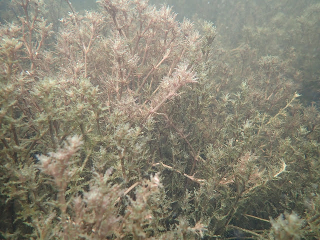
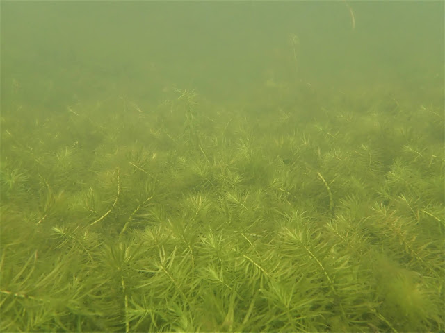
bottom while mapping. The species composition could vary a lot between ponds –
often there were big patches with dense vegetation of just one species, such as
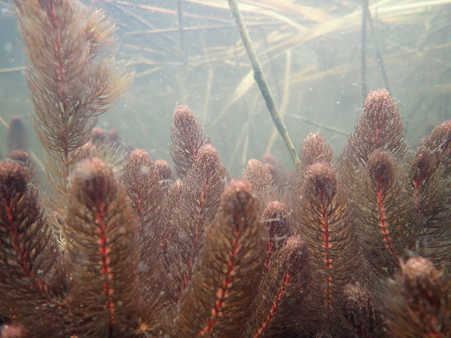
holly-leaved naiad Najas marina, rigid hornwort Ceratophyllum
demersum or even a large field of mare’s tail Hippuris vulgaris. You
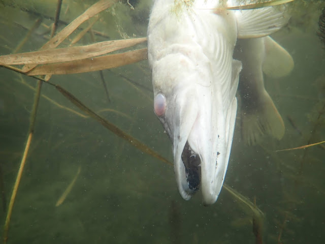
never knew what species would turn up in the next opening (or what else would
turn up, like a big dead pike floating around).
Holly-leaved naiad (Najas marina), Sahanlahti. Photo: Anni Selenius / Metsähallitus Dense meadow of mare’s tail (Hippuris vulgaris) in an opening in the reed belt (Sahanlahti). Photo: Anni Selenius / Metsähallitus Rigid hornwort (Ceratophyllum demersum) with a nice red colour, Sahanlahti. Photo: Anni Selenius / Metsähallitus Surprise pike! Photo: Anni Selenius / Metsähallitus
A slightly different ROI was in the far-away end of Brattnäsviken in Parainen/Pargas, the very last area we mapped in the end of the summer. By then it had already gotten a lot colder – air temperature was only 11 degrees and it was not much warmer in the water (the dive computer we tossed in said twelve degrees, and based on what it felt like I sure believe it). Luckily my teammates weren’t diving then, so I could borrow Pirita’s dry suit which was much warmer than my own relatively thin wet suit.
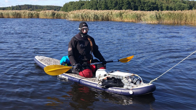
Getting ready for another reed adventure, still happily unaware that I would have to leave the SUP and carry all gear instead. Photo: Patrick Demus / Metsähallitus
The ROI was hidden behind an almost 400 m long, dense reed belt, and I began by making an attempt to walk through that as well, but nope – this time the bottom was loose mud that you sank down in far above the knees with each step, so after spending quite some time trying to get forward with the not-so-impressive result of maybe a few metres and a SUP that was capsized by the reed (with all gear on it), I had to give up and try something else. Luckily, I had realized beforehand that it might be difficult to get through with the SUP, so I had brought with me a waterproof bag to stuff most of the gear in.
I left the SUP in the reed and began my
journey to the nearest shore, carrying all gear first through more reed (but still
significantly less than 400 m!), then along a small field, and lastly on a
small road (yes, still in the dry suit with the mask on my head and flippers in
hand, unfortunately I didn’t meet anyone) before I had to once again walk
through some more reed to reach the ROI. The last bit the bottom became so soft
that walking was completely impossible – I had to press down reed from the
sides in front of me and crawl forward on that.
I have seldom been happier to see open
water than when I finally reached the end of the reed belt and came to the flad
that was to be mapped, after about one hour of adventures to get there. At
least I wasn’t cold by that point. The flad itself was quite big and completely
open, despite being surrounded by a compact wall of reed in all directions. It
was shallow (usually not more than about 50 cm deep) and in big areas the
bottom was covered with a dense, soft mat of Vaucheria, a species of
yellow-green algae that is quite common in such areas, and also occurs inside the
reed belts. The mapping itself was not problematic, but then there was of
course the same journey to get back to the SUP waiting in the bay. To sum up
that field day: Lots of reed and then some more reed.
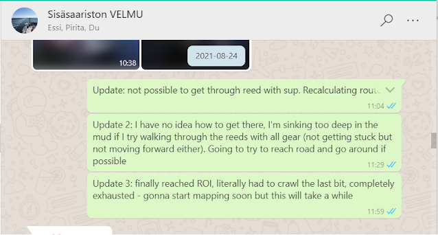
Small positive updates sent to the rest of the team, to let them know how fast my mapping would be progressing. Picture: Anni Selenius / Metsähallitus
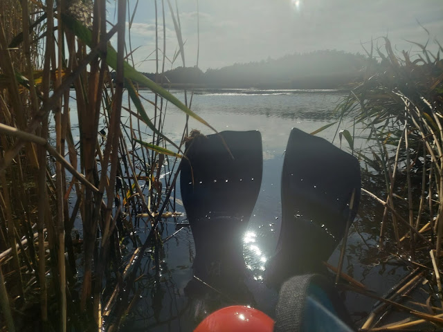 |
| One last look back at Brattnäsviken ROI, the last place I mapped this summer, before heading back through copious amounts of reed. Photo: Anni Selenius / Metsähallitus |
All in all, it has been a very nice and interesting summer, and I had a great work team. I’ve done other kinds of field work and vegetation mapping before, mostly in lakes, but this was the first time I worked for Metsähallitus. Mapping aquatic vegetation is seldom completely obstacle-free, but it is definitely never boring, and you get to see many interesting places you would otherwise never have visited.
Anni Selenius
You can get the feeling of what I did in these videos...